Friendship Peak Trek 2026: A Full Guide to the Cost, Difficulty, Altitude, and Route
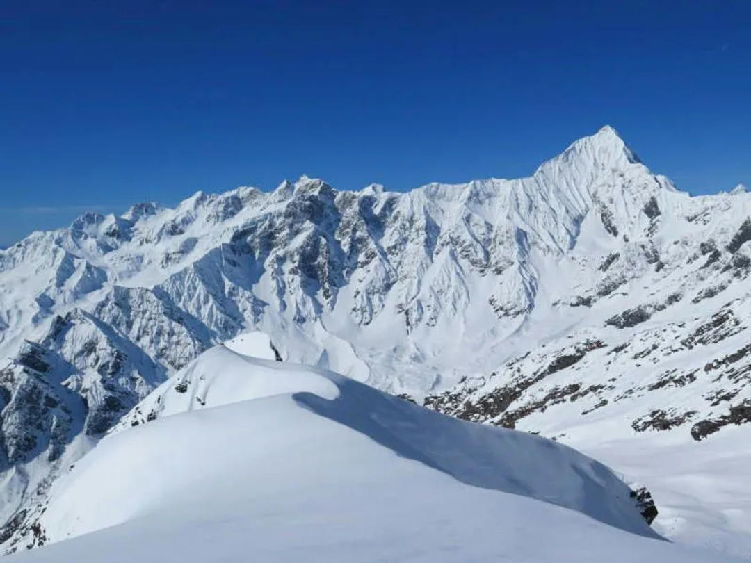
Friendship Peak (17,352 ft / 5,289 m) is one of the most popular summits for beginners to climb in Himachal Pradesh. This trip, which is close to Solang Valley in Manali, is thought to be the best way to get from high-altitude trekking to technical climbing. Friendship Peak has everything a climber might want: crossing glaciers, steep snow slopes, and a spectacular summit ridge.
This extensive SEO-based guide has all the information you need for a Friendship Peak adventure in 2026, including route details, an itinerary, the level of difficulty, fitness requirements, the ideal time to visit, and important preparatory recommendations.
Location and height of Friendship Peak
Height: 17,352 feet (5,289 meters)
Location: Pir Panjal Range, Himachal Pradesh
Manali is the base town.
Solang Valley is the closest access point.
Length of the trip: 6 to 7 days
Friendship Peak is in the Pir Panjal range of the Indian Himalayas. It is one of the best 5,000-meter peaks for beginners because it is easy to get there from Manali and has a well-defined ascending profile.
A Look at the Friendship Peak Route
The trip starts in Manali and slowly moves through beautiful alpine vistas till it reaches glacier area.
The standard route is
Drive from Manali to Solang Valley
Drive from Solang to Dhundi
Trek from Dhundi to Bakarthach
From Bakarthach to Lady Leg Base Camp
From Base Camp to Summit Camp
Push to Friendship Peak from the Summit
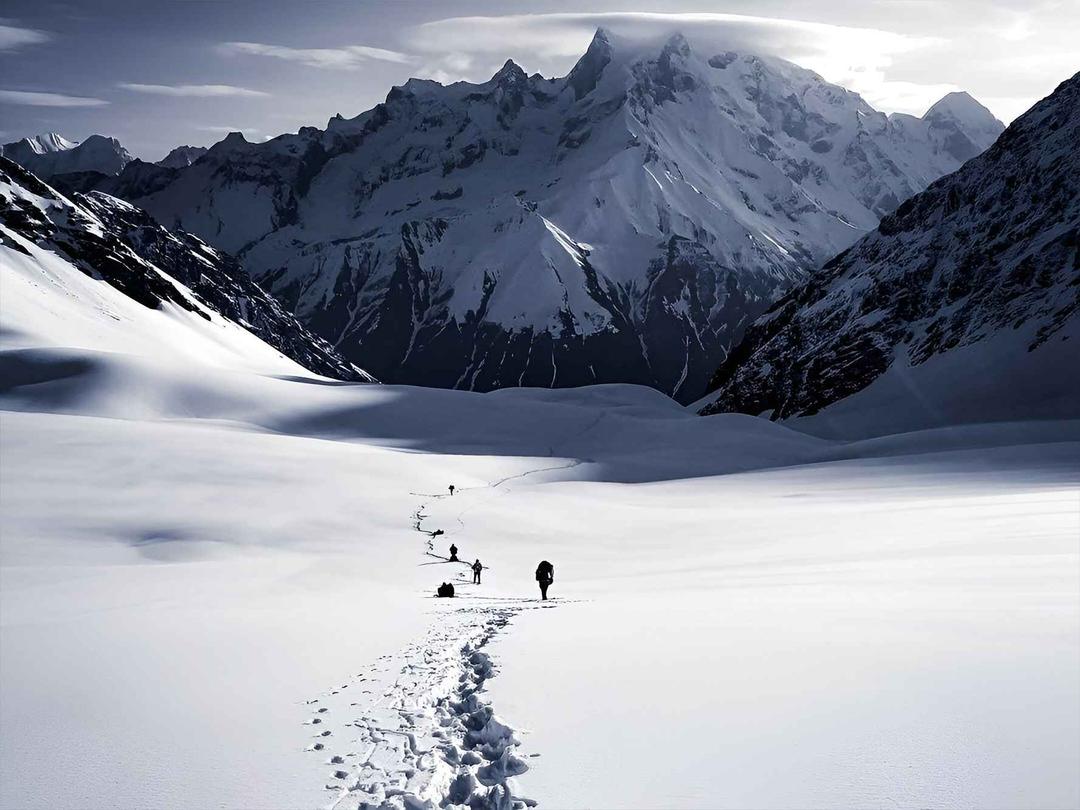
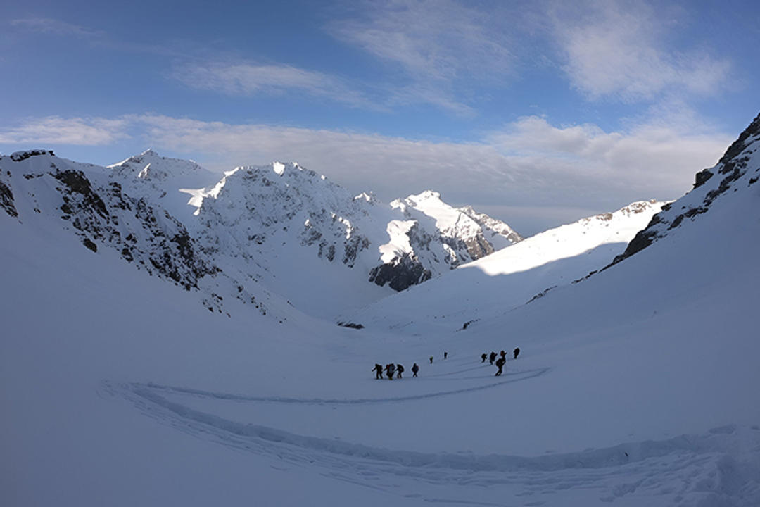
At first, the trail goes through green meadows and river basins, but later it turns into stony moraines and mountains covered in snow. There are difficult snow slopes and climbing with ropes on the peak day.
Friendship Peak's Level of Difficulty
Friendship Peak is rated as moderate to hard. It's not just a walk; it's a tough climbing trip that needs
Using crampons
How to use an ice axe
Parts of the fixed rope
Endurance at high altitudes
This event is good for beginners in mountaineering, however everyone must have hiked at least 12,000 feet before. You need stamina, mental power, and a steady pace to reach the top.
The Best Time to Climb Friendship Peak
Picking the proper time of year is quite important for reaching the top.
1. From May to June (the pre-monsoon season)
Snow conditions that stay the same
Windows at the top are clear.
Great for people who have never climbed before
2. September to October (the time after the monsoon)
The weather in the mountains is clear.
Less chance of an avalanche
Very clear visibility
Stay away from the months of the monsoon since the weather is unpredictable and the ground is slippery.
A Quick Look at the Friendship Peak Itinerary
Day 1: Get to Manali and drive to Solang Valley
Day 2: Drive to Dhundi and then hike to Bakarthach.
Day 3: Hike to Lady Leg Base Camp Day 4: Move to Summit Camp Day 5: Try to reach the summit and then go back to Base Camp Day 6: Reserve Day Day 7: Go down to Manali
A reserve day is included for safety in case of bad weather and to give the summit more time to change, which is important on high-altitude trips.
Friendship Peak's Fitness Requirements
Climbers need to get ready at least six to eight weeks ahead of time. Some suggested benchmarks are:
Running 5 kilometers in 30 to 35 minutes
Ability to walk for 6 to 7 hours per day
Strong legs that can last a long time
Strength and balance in the core
Your preparatory program should include cardiovascular exercise, climbing stairs, doing squats and lunges, and walking great distances.
Training and Tools for Technical Work
Before the summit attempt, climbers learn the basics of:
How to walk with crampons
Practice with an ice axe
Handling ropes
Moving snow down a slope
Some important technological gear is:
Boots for climbing mountains
Crampons
Axe for ice
Harness and helmet
Carabiners
Jacket down
Professional expeditions provide technical gear, but you must bring your own clothes and good walking shoes.
Things that Affect the Cost of Friendship Peak
The cost of the Friendship Peak trip varies on:
How many people are in the group
Including technical gear
Certification for guides
Travel
Camping logistics
Prices may be different, but climbers should put safety, professional leadership, and adequate acclimatization ahead of cheap solutions.
Getting used to things and being safe
It is important to keep an eye on altitude gains above 3,000 meters. The schedule for Friendship Peak includes gentle climbs and stops to get used to the altitude.
Important safety steps are:
Health checks every day
Keeping an eye on hydration
Start of the summit early
Check the weather
Plan B for emergencies
Acclimatization lowers the risk of Acute Mountain Sickness (AMS) by a large amount.
Why Friendship Peak is a Great Place for Newbies
People who are going from trekking to mountaineering commonly recommend Friendship Peak because:
It shows how to travel on glaciers
It teaches how to use ropes.
It gives you confidence at high altitudes.
It gives you a real summit experience.
This adventure requires teamwork, discipline, and mental attention, unlike commercial trekking routes.
Summit Experience
The push to the top usually starts about midnight. Climbers use headlights to climb up snow-covered slopes and hills. As the sun rises, you can see the whole Himalayas, which makes all the work worth it.
Getting to 17,352 feet is a big deal that will change your life. From the summit, you can see all the way around to surrounding peaks in the Pir Panjal range. Be just as careful on the way down, because you'll be more tired after the top.
Responsibility for the Environment
Friendship Peak is in a delicate habitat in the Himalayas. Climbers must obey the Leave No Trace rules:
Stay away from plastic garbage
Be kind to animals
Take back trash that can't be broken down
Follow the guide's instructions
Sustainable climbing makes sure that the mountain stays safe for future generations.
Last Thoughts on Friendship Peak 2026
Friendship Peak is still one of the best places in India for beginners to go mountaineering. It is the perfect way to get started with serious Himalayan climbing because it has a planned schedule, chances to master new skills, and stunning vistas from the top.
If you are in good shape, mentally strong, and with the help of skilled pros, reaching the top of Friendship Peak in 2026 is a realistic and satisfying goal.
This trip isn't just about getting to the top; it's also about learning new skills, getting stronger, and feeling the real spirit of the Himalayas.
website
https://www.trekyaari.com/expe....ditions/friendship-p


Bali Pass Trek – A Complete Guide to One of the Most Thrilling Himalayan Treks
If you wish to undertake a ‘Himalayan adventure’ that consists of snow covered trail, high mountain passes or the beautiful sight of the valleys, Bali Pass Trek is for you! This journey links the stunning Har Ki Dun Valley with the sacred Yamunotri Valley for a whirlwind of adventure, natural beauty and spiritual allure.
Read this complete guide where you can find everything about the Bali Pass Trek in terms of route information, difficulty level, and the best time to go on a trek, itinerary and certain tips.
visit-- https://www.trekyaari.com/treks/bali-pass-trek
What is Bali Pass Trek?
Bali Pass Trek is a challenging trek in the Uttarkashi district of Uttarakhand, India. It is about 16,207 feet (4,950 meters) high. The traverse is characterized by steep ascent, glacial ascents, and some of the most stunning views in the Himalayas.
Sankri village which is also the base camp for a lot of famous treks- like Kedarkantha and Har Ki Dun, is from where the trek commences. From Sankri, trekkers trek through beautiful woods, old villages and green grasslands and then arrive at the exciting Bali Pass.
Why Choose Bali Pass Trek?
Bali Pass Trek is not just like another mountain trek. It gives you the full Himalayan profile.
Stunning Mountain Views
From the Bali Pass summit some of the popular peaks visible are:
Swargarohini
Bandarpoonch
Black Peak (Kala Nag)
Garhwal Himalayan ranges
Adventure and Challenge
This hike is an adventure for the intrepid. The ramp up to the pass, the snow fields and glacial sections are interesting.
Beautiful Valleys
You will walk through:
Har Ki Dun Valley
Ruinsara Tal
Osla Village
They are reputed for their natural landscapes and tranquil environs.
Spiritual Touch
Close to Yamunotri Temple, one of the Char Dham pilgrimage circuit sites, the trek terminates.
Bali Pass Trek Difficulty Level
The difficulty level of the Bali Pass Trek is moderate to difficult.
Altitude: 16,207 feet
Duration: 8 to 9 days
Long trek hours: 6-8 hour’s walking in a day
Steep ascents and descents
This trail is for those who are experienced in trekking. Beginners can do it too, but strong physical fitness and preparation is required.
Best Season to Do Bali Pass Trek
Picking the right timing is key for a safe and fun ride.
Summer Season (May to June)
Snow at higher altitudes
Clear mountain views
Pleasant weather
This is the best time for Bali Pass Trek.
Post-Monsoon Season (September to October)
Clear skies
Less snow
Beautiful landscapes
Monsoon must be evicted because of land slide and slippery ways.
Route and Itinerary of Bali Pass Trek
A brief summary of the Bali Pass Trek itinerary:
Sankri to Seema via Taluka
12 km12 km8,500 ft
Seema to Rainbasera
10 km10,200 ft
Rainbasera to Ruinsara tal
7 km11,800 ft
Ruinsara Tal to Odari
4 km13,100 ft
Odari to Bali col camp
5 km15,100 ft
Bali Col camp to Lower Dhamni via Bali Pass
14 km16,200 ft
Lower Dhamni - Jaan Ki Chatti
8 km8,500 ft
Highlights of Bali Pass Trek
Har Ki Dun Valley
A scenic cradle shaped valley itself surreal with alpine flowers and snow-capped peaks alluring more and more travellers.
Ruinsara Tal
So peaceful and picturesque, a lake with trees and mountains.
Bali Pass Summit
And this is the most exhilarating part of the trek. Snow fields and wide views make it one of the most memorable.
Yamunotri Temple
The Hindu goddess Yamuna is worshipped at a revered Dios temple.
What to Pack for Bali Pass Trek
It is a very packing the right gear.
Clothing
Warm jackets (down jacket)
Thermal wear
Waterproof jacket
Trekking pants
Woolen cap and gloves
Footwear
Good quality trekking shoes
Extra socks
Essentials
Sunglasses
Sunscreen
Water bottle
Trekking pole
Personal medicines
Being a high altitude trek holder, temperatures at Bali Pass can dip sharply.
Fitness Preparations for Bali Pass Trek
Physical endurance is a must as the journey is gruelling.
Cardio Training
Begin running or fast walking 4-5 weeks before the trek.
Strength Training
Focus on:
Leg exercises
Squats
Lunges
Core workouts
Breathing Practice
High elevations typically lack abundant oxygen. Practice deep breathing exercises.
Bali Pass Safety Tips Warmed up and ready!
Never trek alone—always hire a knowledgeable guide or go with a trekking group.
Stay hydrated.
Walk slowly and steadily.
"Try not to blow off any signs of altitude sickness.
Follow your trek leader’s instructions.
The most important aspect of high-altitude trekking is security.
Cost of Bali Pass Trek
The Bali Pass Trek cost varies from ₹18,000 to ₹25,000 and it all depends on the trekking company and what all is being offered.
The cost generally covers:
Accommodation
Food during the trek
Trek guide and support staff
Permits
Some packages come with/without transport to/from Dehradun.
Who Should Do Bali Pass Trek?
This trek is ideal for:
Adventure lovers
Experienced trekkers
Nature photographers
Those seeking Himalayan treks that are less touristy
If you are looking for a calm and exciting experience far from crowded tourist destinations, Bali Pass is your go to someday.
Last Words about Bali Pass Trek
The Bali Pass Trek can be considered as one of the most rewarding and thrilling treks in Uttrakhand. Green valleys, tranquil lakes, snow-covered passes and sacred temples; this trek gives you everything in one go.
It’s not easy going, but it is worth the effort. Nothing compares to the feeling of standing on 16,207 feet with unobstructed views of the Himalayas that you will not forget for a lifetime.
If you are looking to one of the real Himalayan adventure, workout for Bali PassTrek and feel magic of mountains.
Gaumukh Tapovan Trek: A Complete Guide for Nature Lovers
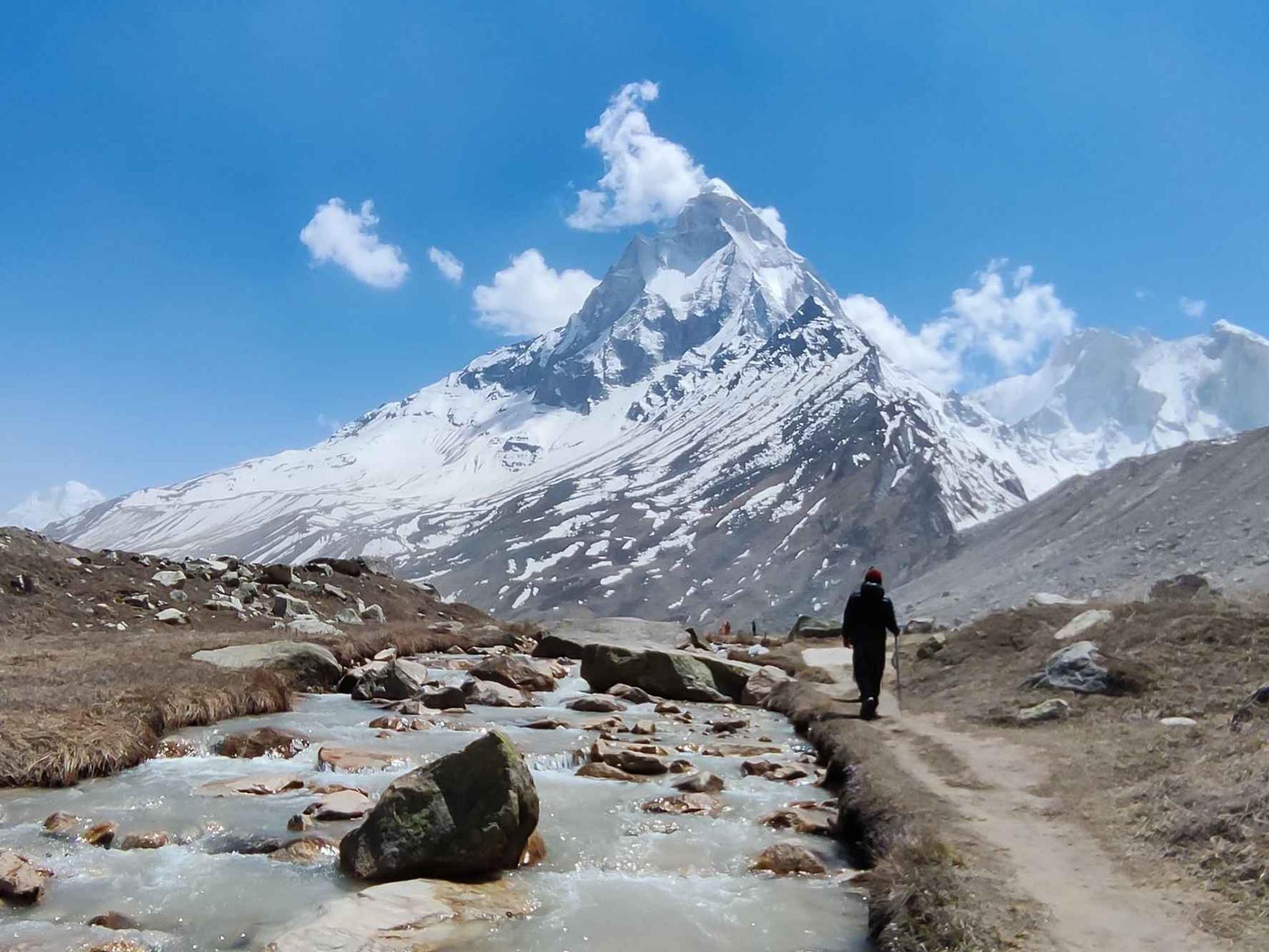
The Gaumukh Tapovan Trek is one among the most beautiful as well as spiritual treks in India. Situated in the Garhwal Himalayas of Uttarakhand, this area of Nanda Devi and Valley of Flowers are close to the headwaters of the Ganges River and offers breathtaking scenery with snow-capped mountains, vast meadows, clear waters which gives a feeling of serenity. It is not just a hike; it is such an emotional experience.
This would be good for anyone who enjoys Mountains, nature – more on this later and quite places. If you are adventure and spiritual traveler then Gaumukh Tapovan Trek is one of the best trek for you.
What is Gaumukh Tapovan Trek?
The starting point of Gaumukh Tapovan Trek is Gangotri, the sacred town. 8212; Gnm389 }} The source of the Bhagirathi River, is Gaumukh at the foot of a glacier. The word “Gaumukh” is a Sanskrit expression, which mean cow’s mouth as it looks like face of a cow.
The high meadow is above the Gangotri glacier. It provides magnificent landscape views of Mount Shivling, Bhagirathi group of mountains and Meru Parvat. The pilgrimage offers a mix of spirituality, adventure and naked Himalayan beauty.
Visit--- https://www.trekyaari.com/trek....s/gaumukh-tapovan-tr
Why Choose Gaumukh Tapovan Trek?
There are various factors why trekkers opt for this trail:
Source of River Ganga You go to see the place where you find river ganga.
Stunning views of Mount Shivling
Peaceful alpine meadows at Tapovan
A blend of glacier walks, rocky hills and green valleys
A spiritual and calm environment
Not as crowded as the famous treks
This trek is the best bet for people looking out for a meaningful and dramatic Himalayan experience.
Best Time to do Gaumukh Tapovan Trek
The prime time to do the Gaumukh Tapovan Trek is between May till June and September till October.
Summer (May to June)
Pleasant weather
Clear mountain views
Snow still seen on upper mountain peaks
Autumn (September to October)
Clear skies after monsoon
Fresh air and sharp views
Cold nights but stable weather
Monsoon season (July–August): Meet a mist soaked death via temples, slipping on rocks and falling down a ravine. Similarly not convenient is the winter season when snowfall is large and cold extremes occur.
Trek Distance and Difficulty Level
Total Distance: Approximately 46 km (out and back)
Duration: 6 to 8 days
Maximum Elevation: Around 14,600 feet (Tapovan)
Difficulty Level: Moderate to difficult
The journey includes glacier walks, steep climbs and high altitude, so it should be done by individuals who have some trekking experience. It’s something beginners with good fitness and preparation can do, too.
Detailed Trek Route
Day 1: Reach Gangotri
Gangotri is the starting point of the trek. You can drive here from Dehradun or Rishikesh. Take it easy and acclimatize for the day.
Day 2: Gangotri to Chirbasa
This path is through pine and birch forest. By your side is the Bhagirathi. The walk is a leisurely and picturesque one.
Day 3: Chirbasa to Bhojbasa
The land opens up and becomes more rocky. Bhojbasa is the only human habitation along this route. From here the Bhagirathi peaks can be seen distinctly.
Day 4 – Bhojbasa to Gaumukh and Tapovan
This is the hardest and most satisfying day. First, you reach Gaumukh Glacier. Beyond that, a steep ascent guides you to Tapovan, where verdant lawns lead to breathtaking panoramas of Mount Shivling.
Day 5: Explore Tapovan
Spend a day exploring Tapovan. There are meadows to walk around, meditate in or just enjoy the quiet.
Day 6–7: Return to Gangotri
Return journey is to be taken through the same route back to Gangotri.
Natural Beauty Along the Trek
The Gaumukh Tapovan Trek brings you nature’s riches:
Snow-covered Himalayan peaks
Massive glaciers
Green alpine meadows
Clear mountain rivers
Blue skies and starry nights
You may also be lucky to spot wildlife such as blue sheep and Himalayan birds.
Spiritual Importance of Gaumukh Tapovan
This is a pilgrimage of great spiritual importance. Gaumukh is a holy place as this where the Ganga originated. There is a strong energy and peace in Tapovan, many saints and yogis meditate in this area.
Quite frequently you will see sadhus walking barefeet or sitting quietly in such meadows. The tranquillity allows you to untether from the world of your every day, and to tether with yourself.
Required Permits and Documents
Forest department permit required for the Gaumukh Tapovan Trek.
Permits are issued in Gangotri
Carry a valid ID proof
A certain number of trekkers are accepted each day, apply early !
When you book through most trekking companies, they help arrange permits for you.
Fitness and Preparation Tips
Good preparation is valuable for this hike:
Begin running or jogging 3–4 weeks in advance
Go up and down the stairs while wearing a back-pack
Do breathing exercises for altitude
Bring warm clothes and good walking shoes
Stay hydrated during the trek
Good physical conditioning makes the journey safer and more enjoyable.
What to Pack for the Gaumukh Tapovan Trek
Some important items include:
Warm jacket and thermal wear
Trekking shoes with good grip
Sunglasses and sunscreen
Reusable water bottle
Basic medicines and first aid
Rain jacket and gloves
Pack light but smart.
Conclusion about Gaumukh Tapovan trek
Gaumukh Tapovan Trek is an amalgamation of adventure, nature and spiritualism that every trekker wants to experience in life. It pushes your body and soothes your mind, creating memories you’ll never forget. The route to Mount Shivling and calm meadows of Tapovan and the holy Gaumukh Glacier will give you the feeling for this particular trek.
If you are in search of that Himalayan trek which is more than just about walking and actually leaves its imprints on your soul by connecting you well with nature and most importantly, yourself then Gaumukh Tapovan Trek should be there on your radar.
Buran Ghati Trek – A Complete Guide to One of Himachal’s Most Beautiful Adventures
The trek feels like this because it’s one of the rare Himalayan treks that has everything. It features green meadows, thick forests, charming villages, snowfields and an exciting high-altitude pass crossing. This trek in Himachal Pradesh bridges the stunning Pabbar Valley with Baspa Valley and is ideal for those that want a little bit of beauty and adventure.
If you are somebody who has dreams of exploring unsullied terrains, walking on a snow adorned inclines and night Camping under the star spangled sky then you will get all of this in plenty during Buran Ghati Trek.
What Makes Buran Ghati Trek Special?
What makes the Buran Ghati Trek so special is – its diversity over a few short days. Every day feels different. You’ll be strolling in apple orchard and traditional villages one moment, then find yourself among snow and looming mountains the next.
The trail’s spectacular pass crossing at approximately 15,000 feet is also a highlight – and usually snow-covered in early summer. Sliding down the snow wall on the other side of the pass is something many trekkers regard as an unforgettable experience.
Visit-- https://www.trekyaari.com/treks/buran-ghati-trek
Starting Point – Janglik Village
The journey starts from Janglik a small and beautiful village, as if pasted from a postcard. With wooden houses, slate roofs, narrow paths and the ever-amiable natives; Janglik is a beautiful place to kick-off trekking.
A walk through the village is an insight into traditional Himalayan living. There’s a slow but orderly pace, it’s peaceful and connected to nature.
Beautiful Campsites Along the Way
Best part of Buran Ghati Trek – Campsites One of the major attraction of Buranghati trek are the camping grounds. Each campsite has its own personality and ambiance.
Dayara Meadows: Picturesque lush green meadows ringed by forests and mountains. Great for chillin' and enjoying the scenery.
Litham: a peaceful camping place by the river and snow peak all around.
Dunda: The second and last Camp site before the pass, mostly snow bound.
These camping spots make you feel like you’re an urban escape, and let’s face it — sometimes the only sounds you should be hearing are of trickling water and wind through trees and birds.
Forests, Meadows, and Rivers
The landscape changes as you continue your way on the trek. You stroll through stands of towering pine and oak, walk across wooden bridges spanning icy streams and amble on wide-open meadows bursting with wildflowers in summer.
In the spring and early summer there is still snow in places on the trail, adding to the excitement of walking it. The rivers that you cross are pure and clean, directly from melting glaciers.
Crossing the Thrilling Buran Ghati Pass
The highlight of the trek - you cross the Buran Ghati Pass. The ascent to the pass is long and arduous but the views from top are breathtaking.
At the pass, you can see surreal snow covered mountains as far as your eyes can see in all directions. On the descent, meanwhile, one typically goes down by rappelling along a snow wall that makes for a real-life amusement-park ride in the heart of the Himalayas.
For many people, this moment is the single greatest highlight of treks.
Who is eligible for the Buran Ghati trek?
The Buran Ghati Trek is ideal for a fit beginner and an experienced trekker. It’s not super technical but it is physically demanding due to long walking days and elevation.
If you are able to walk leisurely for a few hours daily and before the trek get into shape, you can fully enjoy this experience.
Ideal Time for Buran Ghati Trek
Buran Ghati Trek can be best done in the months of May and June & September and October.
May – June: Snow, stunning scenery and thrilling pass ascent May typically means snow terrain, dramatic landscape and exciting pass crossing!
September and October: Blue skies, fall colors, beautiful mountain vistas.
Both will have slightly different experiences based on the season, though both are equally stunning.
Culture and Local Life
Another lovely aspect of this trek is the cultural experience. You pass by isolated villages where the people are still living traditional lives. The wooden houses, indigenous temples and plain way of living are a cultural boost to the trip.
The locals are friendly and welcoming, often waving at trekkers out of curiosity.
Why This Trek Stays With You
Buran Ghati Trek is more than getting to a place it’s about journeying through that place! The continual variety of scenery keeps your mind engaged, and the quiet environment allows you to escape daily stresses.
This trek is often described by many trekkers as two or three different treks all rolled into one. Amazing this trek has everything and it fits together beautifully: meadows, forest, snow, village and high pass.
Our Experience and Recommendation
When you are preparing for something as exciting as the Buran Ghati Trek, it is good to try and get things into place properly. We did this trek with TrekYaari and it was very smooth, safe (in terms of preparedness) ordeal saving us from the trouble of any operational hassles and letting us simply enjoy the mountains.
Final Thoughts
The Buran Ghati Trek is an awesome pick for those seeking an all round Himalayan experience in a packed itinerary. It combines the beauty of nature, exciting experiences, cultural exposure and undisturbed peace and tranquility all in one trip.
Whether you are a beginner or an experienced trekkers, this trek gives something new to everyone. After you’ve hiked across its meadows and forests, over snowy passes where the air freezes in your lungs, the memories last a lifetime.
If mountains are calling you, Buran Ghati Trek might be the answer.
Hampta Pass Trek – A Complete Guide for Beginners and Nature Lovers
The Hampta Pass Trek is among the most stunning and beginners-friendly high altitude treks in India. This trek is in Himachal Pradesh and links the lush green Kullu Valley to a cold high-altitude desert valley of Lahaul. What is so special about the Hampta Pass trek are the rapid and extreme contrasts in landscapes. Perhaps more incredulously, just a few days’ walk and you meander open forest, treacherous avalanche slopes, rocky valleys deep with snow bridges then emerge onto the desolate dry steppe of a land altogether unlike that from which you began.
A trek for the people who are looking to do Himalayan trek without having a high fitness level or any prior experience. It’s an adventure, beautiful and varied — packed into a short time span.
Visit-- https://www.trekyaari.com/treks/hampta-pass-trek
Where is Hampta Pass Located?
Hampta Pass Trek is situated at an elevation of approximately 14,100 feet in Himachal Pradesh. The trek begins in the vicinity of Manali typically at a little village named Jobra or Prini. From there, the trail enters verdant valleys and concludes in Chhatru, of Lahaul.
It's a fact that Manali is easily accessible by road and this makes the starting point of Hampta Pass trek fairly simple to reach in comparison with most other Himalayan treks.
Why Choose Hampta Pass Trek?
Why is Hampta Pass trek popular:
It is perfect for beginners in the trekking world
The duration of the trek is brief (4–5 days).
You get several views on a single walk
The elevation is high but not insurmountable
You can include Chandratal Lake for the visit after trek.
If your looking for a trek that has a complete Himalayan offering and not too gruelling at the same time, hop on to Hampta Pass.
Best Time for Hampta Pass Trek
The ideal time to undertake the Hampta Pass trek is between June and September.
June: Snow is still present. You walk on snow bridges and enjoy dramatic views of others.
July-August: Green meadows, colorful flowers and flowing streams. This is the most scenic time.
September: Cool weather, bright skies and little traffic, sharp mountain views in the less foggy hills.
The trail is impossible to pass in winter due to heavy snowfall, and too dangerous in early monsoon if the weather is not stable.
Hampta Pass Trek Itinerary – Route & Map
The trek route Here is an easy to follow visual idea of the trek’s route:
Day 1: Manali - Jobra, Trek to Chika –9-10 hours Today was the first day of our trek.
You drive from Manali to Jobra and begin trekking towards Chika. The path winds past forests, across grassy fields. It’s a low-impact, laid-back day!
Day 2: Chika to Balu Ka Ghera
This date has you walking along the river, and stepping over small streams. The valley widens, and I can feel the mountains around me. Balu Ka Ghera is a broad valley with tall peaks on either sides.
Day 3: Balu Ka Ghera – Hampta Pass – Shea Goru
Today is the hardest, most invigorating day. You head in the direction of Hampta Pass and have great views from half way up. Later that day you descend into the dry valley of Lahaul, camping at Shea Goru.
Day 4: Shea Goru to Chhatru, drive to Chandratal
The landscape changes completely here. Green turning to brown mountains, it’s like a different world. You may also pay a visit to Chandratal Lake if the weather and roads are good.
Challenges Faced on Hampta Pass Trek
Hampta Pass trek is easy to moderate. You don’t have to be an experienced trekker, but basic fitness is a must. You need to be able to hike 5 hours a day with breaks.
Some challenges include:
Steep ascent on pass day
Walking on snow (early season)
Cold weather at night
With adequate preparation and the right support, almost anyone can complete a trek comfortably.
Fitness and Preparation Tips
For an exciting trek on the Hampta Pass, it is advisable to start preparing at least 3–4 weeks before you head out.
Simple preparation includes:
Daily walking or jogging
Climbing stairs
Stretches 6 light strength leg and core exercises
Mental preparation is also important. Trekking requires patience, teamwork and flexibility.
What to Carry for Hampta Pass Trek
You will be surprised how much packing smartly matters. Here are some essentials:
Warm layers (fleece, jacket)
Waterproof jacket and pants
Trekking shoes with good grip
Backpack with rain cover
Water bottles
Sunscreen and sunglasses
Basic medicines
Avoid overpacking. Keep the bag light but full.
Meals and Accommodation on the Trek
Overnight: Similarly, the accommodation in Hampta Pass trek is in tents through out. You sleep in beautiful campsites surrounded by mountains and rivers.
Meals are hot, hearty and wholesome. You typically receive Indian fare: dal, rice, vegetables, roti and occasionally pasta or soup. Warm tea is a godsend after a day of walking.
Wildlife and Natural Beauty
Natural beauty abounds in the Hampta Pass area. You may see:
Snow-capped peaks
Glaciers and waterfalls
Wildflowers and green grasslands
The tranquility of the mountains and cool breeze are a nice change from the hot cloud forest.
Is Hampta Pass Trek Safe?
Yes, the Hampta Pass trek is safe when undertaken with good planning and a trustworthy trek operator. Conditions can shift rapidly, so it’s wise to have experienced guides and safety equipment.
The most important rules are to always pay attention to your guide, keep hydrated and ask someone if you’re not feeling quite right.
Final Thoughts
The Hampta Pass trek- where adventure meets the heart of natural beauty combined with ease. It really offers some of the true Himalayan experience without being, sort of, over-the-top. No matter if it is your first trek, or you simply love nature or wish to escape the city life for a short break, this trek offers everything.
From lush green valleys to snow-capped peaks and desert lands, Hampta Pass tells you that mother nature can truly be magical — all in a few days. Its reward: When you finish the journey, you come not only with photos but also stories, confidence and a renewed love of mountains.